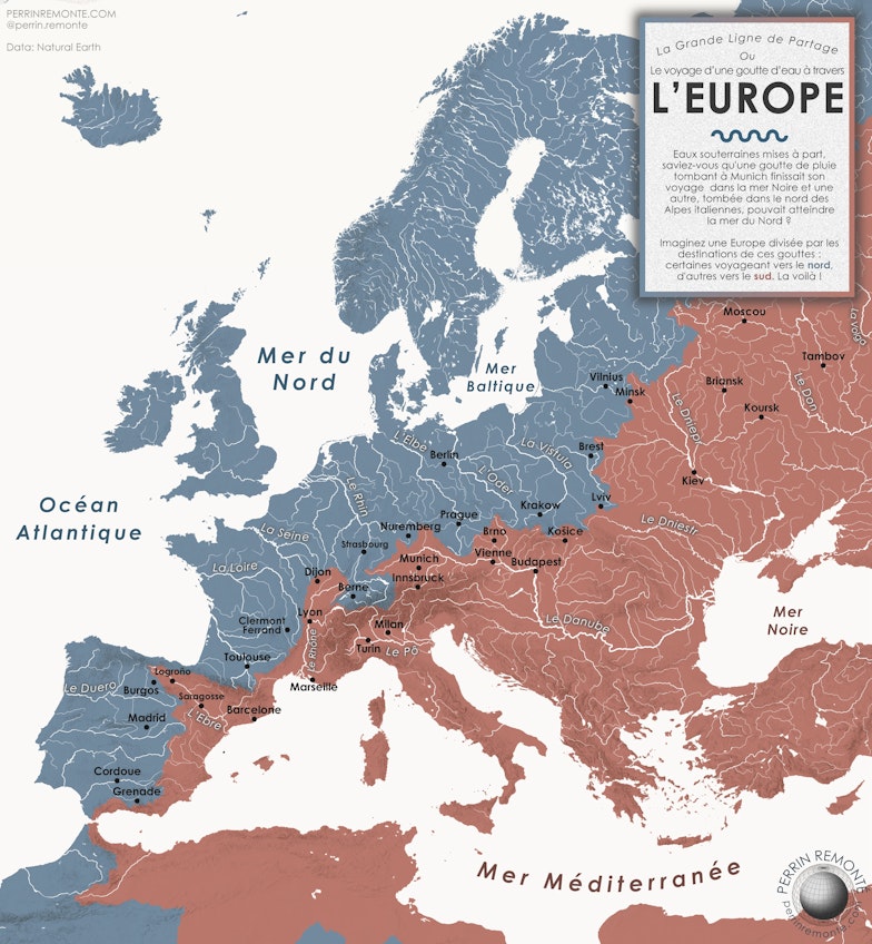
Every week in Cosmorama, a map, an image, a discovery to think about the world differently and take care of it. Today, this magnificent map by Perrin Remonté allows us to draw a watershed divide in Europe.
The European Watershed Divide
A watershed is a geographic area where water is collected by a major river and its tributaries. In short, almost all the water in a watershed flows into a major river, and almost all major rivers flow into the sea or the ocean.
But where exactly?
Depending on the reliefs and the composition of the soil—whether a region is dominated by hard or soft rocks, whether the land’s slope is steep or shallow, and in what direction—it affects how rainwater and melting snow feed rivers.
These waters come from rainfall, snowmelt, tributaries, and underground flows, and almost all of them eventually reach the main river in the territory.
This is what we call a watershed.
On this map, the boundaries of the watersheds form a watershed divide, a boundary that is not just symbolic but also biological and geological. There exists a ridge line that separates two worlds in Europe.
The water divide between the Atlantic and the Mediterranean is remarkable because you can immediately notice a difference in vegetation, especially in the Cévennes and the Grands Causses regions of France.
Watersheds form coherent ecological units.
Curiously, linguistic coherence is also found in watersheds.
It’s as if languages follow the water flow.
As if languages trace the rivers.
More broadly, understanding a watershed is fundamental in any hydrological study, as well as in assessing natural risks and the vulnerability of water resources.
Since the 1950s, rapid urbanization and increasing pollution have led to a rising demand for water, prompting the French government to develop a more efficient water management system by watershed. This resulted in the December 16, 1964 law « on the regime and distribution of water and the fight against its pollution ».
But even during the French Revolution, we knew this.
66 of our departments are named after a river or a river!
Today, France includes 11 major watersheds: six in mainland France and five overseas. The national reference for the French hydrographic network is BD Carthage: [link to BD Carthage]
Learn, understand, and perceive.
The association Initiatives for the Future of Major Rivers (IAGF), chaired by Academician Erik Orsenna, invites us to rediscover the vital and essential character of our rivers.
And to take care of them, just as we take care of ourselves.


