He’s back, and he’s already making headlines. The media even announce a “super El Niño”, with global consequences. But what exactly is it, El Nino? What should we expect, and will it have consequences in France?
Christophe Cassou, research director and author of the IPCC explains in this article what to expect in the coming months, being careful not to fall into media overbidding….
First of all: what is El Niño?
El Nino is a natural climate phenomenon that is part of what is called « the internal variability of the climate system ». This variability refers to the fluctuations that the climate system develops spontaneously, without any external influence (therefore without human influence), due to its chaotic nature.
Behind this somewhat jargon expression, there is actually a familiar daily life. The weather fluctuations we experience, i.e. from day to day or week to week, are the very expression of internal variability in the atmosphere. But there are also fluctuations in longer time scales, from one season or from one year to another, or even from one or more decades to the next. This internal climatic variability then generally involves coupling, an interaction between the atmosphere and the ocean that is dominated by slower processes.
El Nino is the most important phenomenon of internal variability on an annual scale (from one year to the next) and on a global scale of the planet. It develops in the Tropical Pacific and is characterized by a warming of the ocean along the equator, from the Central Pacific to the coasts of South America. In mirror in the atmosphere, winds and rains are altered, coupled with ocean changes. In the atmosphere, we speak of Southern Oscillation or, to emphasize the ocean-atmosphere coupling, of ENSO for “El Nino Southern Oscillation”.
An El Nino event usually begins in the spring (April-May) to culminate in intensity at the end of the year (November-December) along the coasts of Ecuador, Peru and Chile, hence the name El Nino for “child Jesus” in reference to Christmas; it dissipates during the following winter. El Nino events are usually accompanied by heavy and life-saving rains along the Pacific coast of South America, which is usually very dry. Often a blessing for local agriculture but a calamity for fisheries that see their catch of anchovies and sardines collapse, the fish resource having fled from coastal waters that are too hot and unsuitable for their ecological niche. El Nino’s counterpart is called « La Nina ». The ocean is then colder from the Central Pacific to the coasts of South America. This term « La Nina » has no historical essence unlike El Nino (present since the 18th century in indigenous knowledge); it was introduced in the 1990s in climate sciences.
El Nino results in a complete climate disruption throughout the Tropical Pacific with wetter conditions towards South America, drier on the west side towards Indonesia and Australia. Tropical cyclones move towards the center of the basin (Polynesia, etc.). But it is in fact the entire planetary atmospheric circulation that is disturbed by El Nino. Why?
Because the warm Pacific temperatures that cover a very large area (the tropical Pacific represents about a quarter of the world ocean), provide a considerable excess of energy to the atmosphere that warms up to 10-12km altitude over the entire tropical strip at the beginning and a few months later in most regions of the world. We speak of « teleconnection » because El Nino acts remotely, far from its region of development (Figure 1).
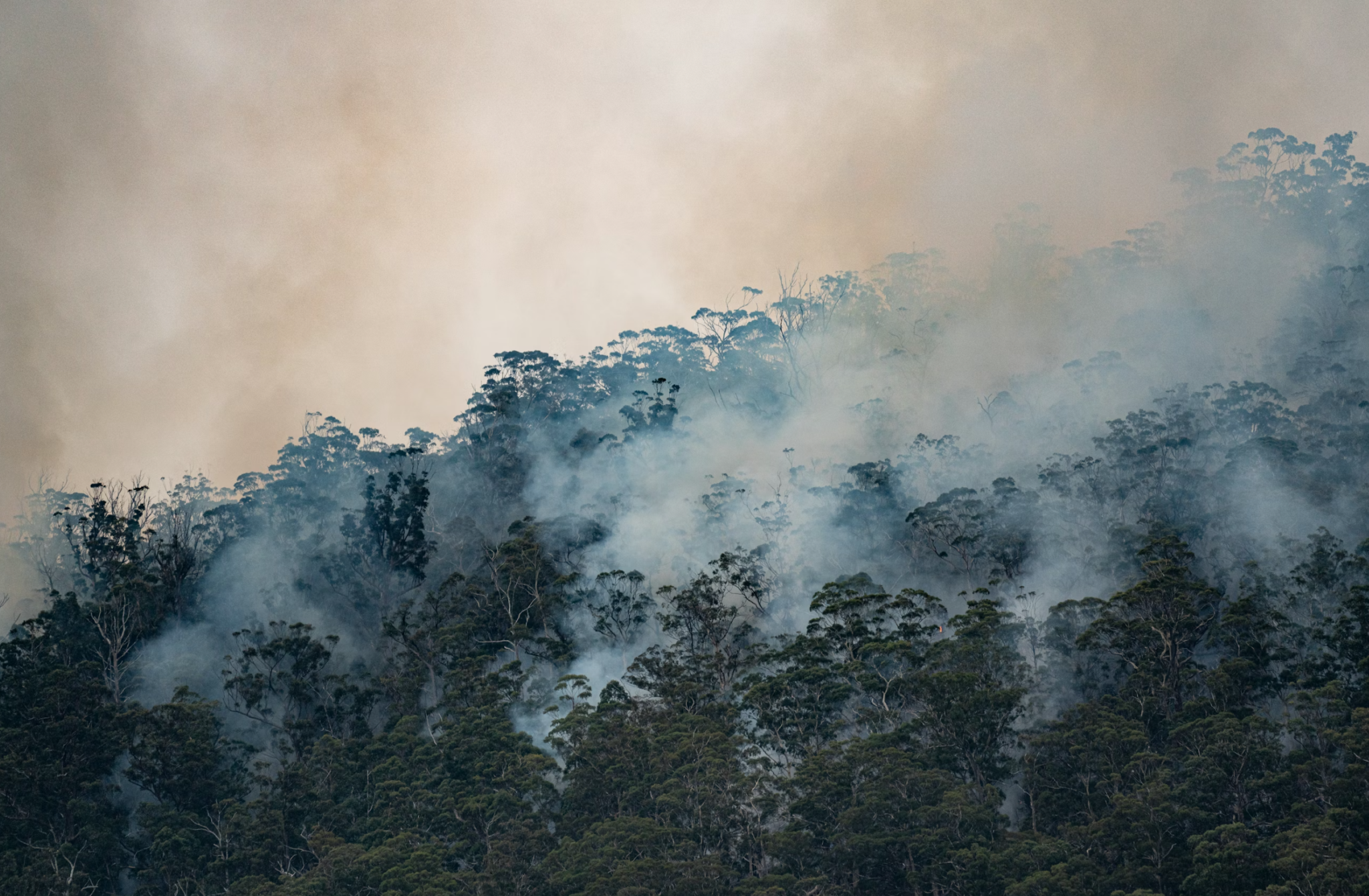
Thus East Africa is wetter while the monsoon further west (Sahel etc.), the Indian monsoon and the rains on the Amazon are generally less generous favoring droughts and fires. The cyclone season in the Atlantic is generally less intense during El Nino. On the North American continent, California is wetter and winters are milder over much of Canada and the Great American Plains.
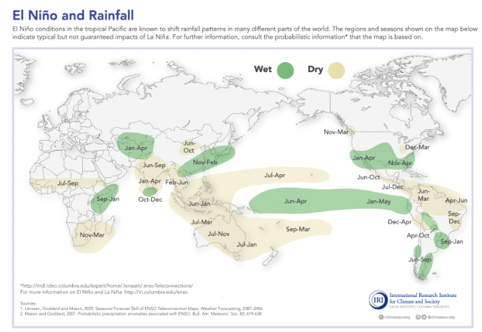
Figure 1: Precipitation anomalies associated with El Nino events (Source)
In short, El Nino/La Nina events have global consequences with beneficial effects on some regions and disastrous for others because they spatially redistribute on the planet extreme events (diluvian rains, heat waves, etc.) that appear in unusual places or that are reinforced. They can change the cycle of the seasons and strain countries that are already vulnerable in terms of water resources and/or agricultural yields, both of which are crucial to ensuring minimum food security.
Why do some media / popularizers talk about a “super El Niño” to come?
The term « super El Niño » refers to the most intense events in terms of temperature anomalies in the Tropical Pacific and intensity in its teleconnections over many regions.
This term « super » El Nino gradually interfered in the scientific literature after the 2000s to qualify the event of 1997/1998 and then that of 2015/2016. It comes from the media sphere, like the term « heat dome », now common in conversations and articles, following the Canadian heat wave in June 2021. Interesting to note here from an epistemological point of view, how communication, very often in search of sensationalism, contaminates discourse and the scientific sphere.
Today in April 2026, we are talking about super El Nino to come because some seasonal forecast simulations (probabistic forecast of climatic conditions of 3 to 6 months of deadlines) suggest the possible development of an intense El Nino event over the next 6-9 months. Its probability is around 1 in 4 chances for NOAA (Figure 2, left) to nearly 1 chance in 3 for the European COPERNICUS consortium (Figure 2, right).
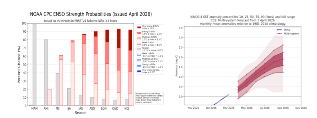
Figure 2: (left) Probabilistic forecast of the ocean surface temperature anomaly on the East Central Pacific [170oW-130oE] around the equator [5oN-5oS] for the seasons from March to January 2027, the super El Nino in brown (Source). (Rate): Temperature anomalies predicted by COPERNICUS (9 models initialized on April 1, 2026), colors representing probabilities (Source)
What level of certainty in El Nino’s forecasts for the coming months?
Based on current observations, whether in the atmosphere (winds, etc.) or in the ocean (heat content in surface layers, etc.), and based on theoretical knowledge (excitation process, etc.), we can say that all the ingredients are present for an El Nino event to be set up right now. The level of confidence in this possibility is very high. The event is being triggered, as shown in the animation below of the ocean surface temperature anomalies (Figure 3) where we can clearly see the cold conditions of a weak Nina present for 1 year.
Figure 3: Animation of surface temperature anomalies from January 8 to April 7, 2026 (Source)
On the other hand, uncertainty remains about the intensity of the planned event and it will be necessary to wait until the beginning of summer to have a more refined estimate of the strength of the El Nino event 2026-2027.
It is important to emphasize that although El Nino events share common physical processes and similar characteristics, each El Nino event is unique in its triggering, temporality, maturity, termination and at the end of the chain, in its teleconnections across all regions of the planet. It is essential to approach your forecast in a probabilistical/statistical way and not deterministically.
Today declaring « a great El Nino is developing » is a misinterpretation or biased interpretation of seasonal forecasts. And scalded cat fears cold water: conditions quite similar to those of this year had been observed in the spring of 2014 and yet the super El nino announced everywhere for the end of the year, did pschitt in July 2014.
An alert for each article posted online, and a weekly letter every Friday, with a summary of the week, infographics, our cultural recos and exclusives.
What are the consequences to expect from El Niño version 2026/2027? Given the current geopolitical situation, will there be additional risks?
Internal variability is superimposed on climate change; it can either amplify or temporarily mitigate its effects. An El Nino event dopes the global temperature of the planet for 2 years.
It is therefore likely that the world temperature record will be broken as warming due to the accumulation of greenhouse gases of human origin continues. Depending on the method we use in the article on the annual update of geophysical climate indicators, there is a 28% chance of breaking the record of +1.52oC of 2024 compared to the reference climate of the late 19th century (1850-1900) (Figure 4a). This probability rises to about 60% in 2027, the El Nino effect being stronger the year following its triggering and the anthropogenic warming increasing each year (Figure 4b).
The threshold of +1.5oC will most likely be crossed this year and next year. Be careful in communication not to put this punctual temperature – one year – on the same level with the 1.5oC anthropogenic warming threshold listed in the Paris Agreement. The latter corresponds to an average over about several years and will probably be crossed in the very early 2030s, or even a little earlier.
It is not El Nino that brings us closer to this threshold of 1.5oC but the emissions of anthropogenic greenhouse gases that are still not decreasing on a global scale, even if their annual growth is lower today than at the end of the 20th century and the beginning of the 2000s. Let’s take the same calculation as above but for the year 2011 where the level of anthropogenic warming was +1oC. What is the probability of crossing +1.5oC in 2011 if a super El Nino had developed this year? About one chance in 150 when it is around 2 chances out of 3 today (Figure 4c)
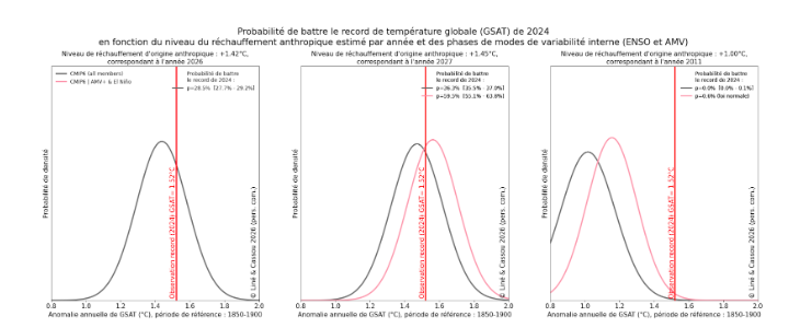
Figure 4: Distribution of global temperature anomalies expected for the year 2026 (a), 2027 (b) and 2011 (c) estimated from the CMIP6 models in the presence (red) or not (gray) of an El Nino event and a hot Atlantic Ocean as expected (Source: Liné and Cassou, personal communication)
Recent studies that are being evaluated in the 7th IPCC report currently being written tend to show in a robust way that in a man-hanged climate, some teleconnections related to El Nino events are strengthened in the tropical strip, with doped rains in the East Pacific or more pronounced droughts in Australia or South Africa in the boreal winter.
In other words, the consequences of the same El Nino in a warmer climate [today] are more pronounced than in a colder climate [50 years ago] and this intensification of the consequences is not linear with a stronger effect of the Super El Ninos. In a warmed ocean, the waves of marine heat that are real fires for fauna and flora, disasters invisible to humans but indirectly impacting via the decrease in fishing resources threatening food security, are considerably strengthened today when an ENSO event occurs.
Global warming increases the vulnerability of populations and ecosystems to internal climate variability, which are additional blows to an increasingly fragile basic state (chronic drop in yields due to high heat and unfavorable water conditions, increasing aridity in all regions with a Mediterranean climate, etc.).
Conflicts such as those affecting the entire Middle East (Iran, Lebanon, Palestine, etc.) are an additional source of immense vulnerability for local populations because critical infrastructure and societal organizations to manage crises in the event of extreme events (heat waves, floods, etc.) modulated by El Nino, are failing.
In France, should we expect special consequences?
There are no statistically robust teleconnections between El Nino events and climate variability in metropolitan France, but strong in the overseas territories in the tropics (see above)
The opportunity to do prebunking here because it is certain that we will read in articles or on social networks that El Nino will be responsible for all evils, if extreme events happen here in France during the next 12 months. On Europe as a whole, the main booster of extreme events is not the ENSO but the accumulation of greenhouse gases in the atmosphere that induces global warming.
In a prospective study, then corroborated by other papers, we had analyzed the changes in ENSO teleconnections in a warmer climate, typically that of the end of the century if we miss decarbonization. We show that ENSO teleconnections with Europe are being established and becoming highly significant. They translate in autumn and winter into more average precipitation over Mediterranean Europe and a deficit further north during the El Nino events.
But it is clear that this signal of climate change is not detectable today at the current level of warming. We can’t see it. Invoking it would be fallacious, as it is fallacious to say today that it rains more on France in winter due to climate change. This assertion is true for the 2nd half of the century if we miss decarbonization but can in no way justify water storage policies today. I will return to this scam and the manipulation of scientific facts in a future article.
What are the key points to remember?
- It is extremely likely (more than 9 chances out of 10) that an El Nino event will develop and affect the planetary climate over the rest of the end of 2026 until spring 2027.
- The April 2026 forecast opens up the possibility (about 1 in 4) chance of experiencing a Super El Nino at the end of the year, i.e. an intense event in terms of warming in the Pacific and/or global teleconnections. It is important to consider this possibility of Super El Nino to anticipate the climate risks that are all the stronger the greater the strength of the ENSO event. We place ourselves in a so-called narrative framework: « if this happens, then ».
- The possibility of a great El Nino is often presented wrongly in a deterministic and almost certain way (we can already find « clickbaits » titles like what would be the « Nino of the century »). This then gives rise to a semantic runaway in the media and on social networks which, at best are misinformation, at worst feeds misinformation.
Bonus: some traps to avoid
- We are climatically in territory certainly unknown to ecosystems and human societies but in an anticipatorable territory. No #WhoWouldHavePredires that doesn’t hold! Science is mature and robust and we follow the overall trajectory given by climate simulations/projections. And our models are also able to simulate super El Nino similar to the one possible this year, as well as its teleconnections.
- This possible super El Nino in 2026-2027 is not a marker of « climate runaway », nor « climate acceleration » estimated by the evolution of global temperature. To date, there is no consensus on the acceleration of global warming, excluding sea level and ocean heat content, both accelerations included, expected and which will intensify until carbon neutrality is reached.
- Today’s extreme events of internal variability should not be considered as climatic ruptures in the physical sense of the term; on the other hand, they can be for ecosystems if during these events, bio-physical thresholds are exceeded, resulting, for example, in massive mortality with irreversibility. In this context, pay attention to communication that drifts towards catastrophism. Take the example of the extreme temperature values in the Atlantic in 2023-2024 then presented as a new standard with increasingly alarmist qualifiers, while these observed values are largely attributable to a very strong episode of internal variability in a warming climate. It is therefore not surprising that the Atlantic Ocean after this « bump » has resumed its « nominal » warming rate (Figure 5). The same drift in the communication on the global temperature jump in 2023, which is attributed today mainly to the fact that the previous years 2021-2022 were too cold compared to the expected climate with 495 +/- 25 billion tons of CO2 accumulated in the atmosphere since the beginning of the industrial era.
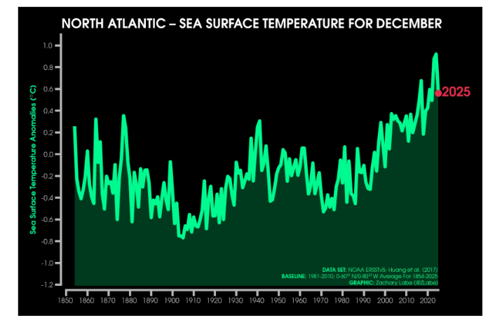
Figure 5: Average sea surface temperature anomaly across the North Atlantic from 1854 to 2025 (Source Zack Labe)
- No surprise in breaking daily global temperature records now and for 12 months in the presence of El Nino while greenhouse gas emissions and land use (deforestation, artificialization, etc.), add about 0.03 degrees [0.02-0.04, confidence interval]. It is not the fact that two El Ninos are close together in time, here 2023-2024 and 2026-2027, that explains the records because the climate system does not have a « great memory » of internal variability but it is because of global warming doped by ENSO.
Cognitive sciences tend to show that a discourse with a catastrophic tone is demobilizing when it is worn « urbi and orbi » in an undifferentiated way. It is mobilizing only on certain categories of population, in certain contexts and contexts.
So, what is the intention of such catastrophic speeches on social networks or in certain media? The simple search for « reach » to satisfy personal interests or the ego? The desire to de facto distance deeper questions about the changes in our society, the political choices to be made precisely to fight against the effects of climate change, which then amounts to focusing on what we suffer and not on the action we should take? A strategy to undermine a form of fatalism?
In any case, science is always a loser with these speeches that are often little anchored on the nature and complexity of the facts. We can be alarming by being factual because the facts even without exaggeration and emphasis are by themselves and simply dizzying.
Source: bonpote