Stopping funding for the global ocean measurement system jeopardizes our weather forecasting and anticipation capabilities – which would ultimately cost far more than the system itself.
Few countries are capable of monitoring the oceans, and the global arrangement that has prevailed until now, on which we depend, is now showing signs of weakness. Europe and Asia must now decide whether to let this system lose its strength or to take back control together.
Currently, in all ocean basins of the planet, a global network of instruments measures the state of the sea.
Research vessels crisscross the oceans, repeatedly following imaginary lines called « transects » to collect data from the surface to the seabed. Anchored buoys monitor tropical oceans, searching for early signs of El Niño or tropical cyclones, and taking the pulse of thermohaline circulation .
Some 4,000 autonomous floats dive to depths of 2,000 meters every ten days before surfacing to transmit temperature and salinity data to ground stations via satellite. Underwater gliders patrol continental margins, and drifting buoys float on the surface in the most remote waters. Hundreds of elephant seals carry miniaturized sensors beneath the polar ice cap…
This network produces invaluable information that allows us to anticipate, react to, and protect the ocean in changing ocean and weather conditions.
However, the ocean monitoring network is fragile, much more so than most people and most governments realize – our new study, published in Nature Climate Change , has measured for the first time just how fragile .
The result is alarming. If observations from just one major contributor, the United States, were removed from the Global Ocean Observing System (GOOS) , errors in our estimate of the ocean’s warming rate would increase by 163%. This is worse than randomly losing 80% of all global ocean data. The reason is geographical: US instruments cover all ocean basins and fill gaps that no other country is currently able to address.
This is not a theoretical concern. Proposed budget cuts to the National Oceanic and Atmospheric Administration (NOAA) and the National Science Foundation (NSF) in the United States now threaten the US contribution to GOOS.
The situation is hardly better on the other side of the Atlantic; and the pressures are not limited to the West. In China, scientists and policymakers are striving to establish a more resilient national contribution to ocean observation, but without the resources the situation demands.
The marine surveillance system on which the world relies is being severely tested almost everywhere in the world.
An observation system in which each component answers questions that the others cannot answer.
Public debates on ocean observation often focus on Argo floats .
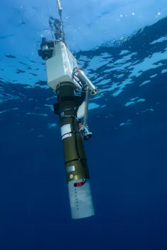
Each Argo float is essentially a watertight cylinder containing pressurized electronic components, equipped with an ingenious buoyancy chamber: it fills with seawater to sink and empties to rise to the surface. Ocean science has been truly revolutionized by the use of these autonomous robots over the past century.
However, Argo is only one element of GOOS and the complementarity of its components is essential.
- Argo profiles the upper two kilometers of the open ocean;
- research vessels are going deeper: GO-SHIP campaigns are conducting surface-to-seabed surveys along repeated transects (crossings) over long distances, providing high-precision reference measurements that allow all other instruments to be calibrated and help validate climate models;
- Anchored buoys provide essential continuous time series for monitoring El Niño, the Atlantic Meridional Overturning Circulation , and the conditions under which tropical cyclones form…
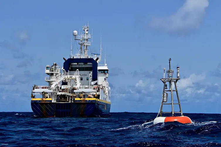
Buoys anchored in tropical waters provide high-quality time series for improved description, understanding, and forecasting of climate variability and change. M. Maupas, Genavir
- Underwater gliders measure coastal currents, eddies and continental margins that floats cannot detect;
- Elephant seals carry sensors into subglacial areas of the polar oceans, inaccessible to any other instrument.
In short, each platform answers questions that others cannot answer.
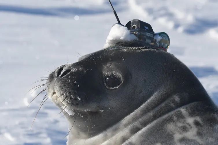
Elephant seals equipped with sensors reveal the secrets of the ocean. C. McMahon, IMOS , Author provided (no reuse)
If one of these elements is removed, the ability of the observation system to provide reliable information degrades not proportionally to the volume of data lost, but proportionally to where the gaps appear.
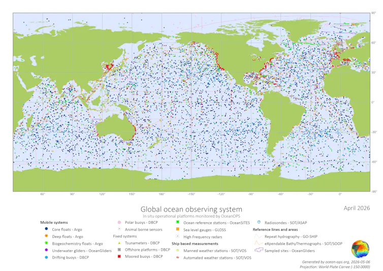
OceanOPS world map showing global ocean observation systems, with colored dots indicating different types of monitoring platforms. OceanOPS , Author provided (no reuse)
What this network actually brings
The Global Ocean Observing System is too often described as a « climate monitoring system », but its role is much broader.
All operational weather forecasts rely on this data. Numerical weather forecasting systems, managed by the European Centre for Medium-Range Weather Forecasts , Météo France , and all other major meteorological services, incorporate ocean observations several times a day.
Without them, forecasts quickly lose their reliability.
Similarly, the new AI-based forecasting systems Pangu-Weather and GraphCast , despite their impressive performance, rely entirely on this same stream of observations. AI does not replace observations; it depends on them.
Subseasonal to seasonal forecasts, which help to anticipate harvest seasons, energy demand and water availability several weeks or even months in advance, depend crucially on knowledge of underwater heat and salinity.
Forecasts of the trajectory and intensity of tropical cyclones, essential for early warning and evacuation decisions, depend on knowledge of the heat contained in the ocean’s underwater layers, and not just on the sea surface temperature. Indeed, hurricanes derive their explosive energy from warm layers located at depths of at least 200 meters.
Marine heatwave alerts , now commonly used by fisheries managers worldwide, are impossible without sustained observation of underwater layers.
Sea level projections used to design coastal infrastructure require decades of consistent measurements, and salinity provides the density information needed to determine all ocean currents, including the Atlantic Meridional Overturning Circulation (AMOC), the great « overturning current » of the Atlantic .
In short, GOOS is the cornerstone of operational services, from tomorrow’s storm warnings to next century’s adaptation plans. GOOS is not a luxury but a necessity.
Why models and AI alone cannot save us
There is a persistent misconception, amplified by the rise of artificial intelligence (AI), that sufficiently advanced models could replace direct observations. This is not the case.
Every forecasting model, whether traditional or AI-based, relies on data assimilation: a continuous adjustment of the simulation to real-world measurements. An AI model trained on a past rich in observations will perform poorly in a present where observations are scarce. In a world where extreme events are increasing and the state of the oceans is changing, historical trends become less reliable.
An observation not made is lost forever. Satellite measurements of the sea surface cannot tell us what is happening hundreds or thousands of meters below the surface, where heat accumulates, currents reorganize, and the precursors of the following season’s weather are already forming. To see beneath the surface, we need instruments in the water.
The cheapest insurance we have
The argument that ocean observation is too expensive collapses in the face of the figures.
The total annual cost of the global system, across all platforms and personnel, amounts to approximately one billion euros worldwide. The European share represents only a fraction of this.
Extreme weather events linked to ocean conditions caused tens of billions of euros in damage across Europe in 2024 alone.
A single major hurricane season in the North Atlantic can cost the United States hundreds of billions of dollars. Marine heatwaves have devastated billion-dollar fisheries and caused massive coral bleaching on reefs worldwide. Inaccurate seasonal forecasts have cascading effects on agriculture, energy, and humanitarian aid, with consequences that are rarely quantified.
Every euro spent on ocean observation yields a return several times over. It is one of the most profitable public investments there is.
The choice of Europe
Europe must consider ocean observation as a critical infrastructure, on par with satellite navigation or meteorological services. This implies stable, multi-year funding for the operational backbone of the system: buoys, ships, moorings, underwater gliders, and the data centers that process and disseminate the data.
France possesses the second largest exclusive economic zone (EEZ) in the world. Present in the Atlantic, Pacific, and Indian Oceans, France comprises five overseas departments and regions, as well as seven overseas collectivities, home to 2.7 million French citizens. Yet, France contributes only about 5% of global data on ocean temperature profiles.
Australia’s contribution is more than three times greater.
The European Union contributes approximately 12%, less than a quarter of the American share. Europe, and France in particular, should significantly increase its contribution.
OceanObs’29 , the decennial international conference to be held in China in 2029, is an opportunity to negotiate a more balanced global system, reflecting economic capabilities and maritime interests rather than an accident of history.
Scientific cooperation between Europe and China should intensify, as their observation areas are largely complementary. Together, they would cover a large part of the world’s oceans.
An opportunity that will close if we allow the network to deteriorate.
The danger lies in the progressive erosion of information on which an increasing part of human activity and the blue economy now depends .
Cyclone warnings are becoming less reliable, seasonal forecasts less precise, and sea-level projections less accurate. Each loss may be tolerable individually. Together, they amount to blindly advancing toward the most consequential climate transformation in human history.
The ocean observation system is a global public service, built up over decades by many nations. France and Europe possess the institutions, expertise, and maritime interest necessary to play a much more significant role.
What’s lacking is the political will to act, while the system can still be maintained. The loss of collaboration between nations would necessitate a far more difficult and costly reconstruction than sustained investment in what already works.
source : the conversation