While the coolness is gaining ground in Western Europe at the start of the week, hot air is invading the eastern part of the Mediterranean basin. A scorching week begins between southern Algeria and the western coast of the Black Sea.
By communicating mud effect, the cold air falling over Western Europe, on the contrary, lifts the warm air further east. A significant temperature contrast is emerging between western Europe and south-eastern Europe.
Rise of subtropical air from the Sahara
Superheated air is currently rising from the Sahara towards Eastern Europe. The air mass is expected to continue to warm up in the coming days, reaching up to +30°C at 1500 m on Wednesday over southern Turkey. This heat dome extends from southern Algeria to the west of the Black Sea, passing through Greece, Libya and Turkey. This Monday, a southern part of Romania and Serbia was already on orange alert for expected high temperatures.
Up to 48°C in Algeria and 43°C in Greece
This Monday, very high temperature values were already recorded in southern Algeria with 45 to 47°C, up to 37°C in southern Romania and 40°C in Turkey. The subtropical air mass present as far as Romania at the start of the week will sink a little towards the south in the coming days. Romania and Serbia will therefore emerge from the extreme heat. On the other hand, Wednesday and Thursday are expected to be the hottest days in Türkiye or Greece. We expect up to 43°C in Lamia in central Greece, 40°C in Sparta (southern Greece) and 41°C in Izmir (Turkey).
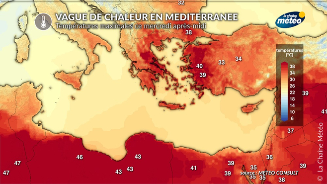
Maximum temperatures Wednesday ©
This wave of severe heat will end in southern Europe next weekend. The heat dome will sink a little further and will be limited to northern Africa. Nevertheless, temperatures will remain high, but closer to seasonal norms.
Source: actualite.lachainemeteo