To protect Posidonia meadows from the onslaught of our anchors, anchoring rules in the Mediterranean have become stricter in recent years, and skippers are liable to heavy fines. Here’s the lowdown.
1/ Understanding the ecosystem role of Posidonia
Posidonia is an endemic plant found along the Mediterranean coast, at depths of between 0 and 40 meters. It is not very common in Occitania, but covers 33% of the PACA coastline and 66% of the Corsican coastline.
It’s THE undersea star in terms of ecosystem services: it filters water, sequesters carbon, produces oxygen (1 m² of seagrass produces 14 liters of oxygen per day) and is home to numerous species of fish. What’s more, it protects against erosion by absorbing swell and fixing soft bottoms.
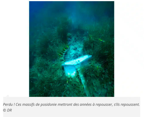
But the Posidonia is fragile and threatened by yachting, coastal development, urban stormwater systems, changing currents, etc. The assault of our anchors and the avoidance of our chains are one of the main threats to its survival.
That’s why the relevant authorities have been racking their brains for years to try and preserve it, by creating protected reserves and no-anchoring zones for certain vessels.
So, yes, it requires a bit of concentration on the map, but in the end, it’s the survival of the seagrass beds (and that of underwater biodiversity) that’s at stake
2/ Progressive regulations
Posidonia has been a protected marine species since 1988, and in recent years new regulations have been introduced along the Mediterranean coast.
Frigate Captain Pierre-Louis Josselin, spokesman for the Préfet Maritime de la Méditerranée, explains: “The 2019 decree organizes the anchoring of large vessels over 45 meters and delimits specific anchoring zones. In addition, local decrees regulate and prohibit certain areas for anchoring vessels of 20 to 24 m (and more). These zones have been the subject of lengthy consultations between sea users, environmental associations and the sector’s socio-economic players, in order to remain as close as possible to local issues”. In all cases, anchorage must not exceed 72 hours, and this applies to all vessels.
The authorities initially opted to raise awareness rather than issue fines.
3/ Understanding ecological damage
The France Nature Environnement PACA association has been a civil party in the first “posidonie” cases, in order to raise public awareness of the consequences of its destruction and to establish a body of case law on this ecological damage.
But how to estimate it? In its plea, the association relied on two calculation methods, detailed by its lawyer Maître Vergnoux.
The first method involves estimating the ecosystem value of the services provided by Posidonia meadows. “In concrete terms, this involves multiplying the abrasion surface of the anchor and chain by the ecosystem value (an average derived from two field studies in Corsica and Italy) multiplied by 25, the average number of years it would take to regrow.
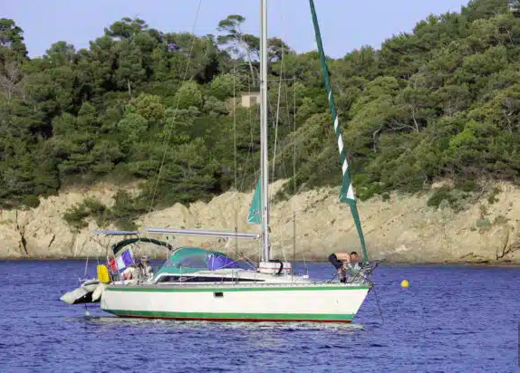
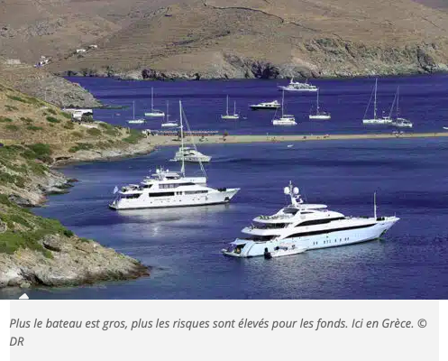
The second calculation estimates the cost of repairing and restoring this destroyed surface. Replanting Posidonia meadows is very expensive: €170/m2 on average. In the case of the Take Off, a 26 m yacht prosecuted for three illegal anchorages between Cannes and Saint-Tropez, the association estimated that the surface area destroyed by its anchor and chain was 981 m2 for these three illegal anchorages.
It therefore estimates the ecological damage at between €213,000 and €246,000, depending on the method of calculation used (ecosystem value or cost of restoration). Quite similar sums… And a strong argument for not dropping anchor just anywhere. Note that the captain has already been fined €20,000 and banned from sailing in French waters for one year.
As for the civil aspect – and the famous case law on ecological damage – we’ll have to wait until next summer for the verdict.
4/ Who can enforce fines against yachtsmen?
The semaphores keep an eye on the coastline and on the AIS, and contact the relevant authorities when an infringement is suspected. Compliance with these new regulations is ensured by authorized agents: the Gendarmerie Maritime, Customs, the French Navy and Maritime Affairs. The infringement must be recorded: simply observing the semaphore, via AIS or binoculars, is therefore not enough to draw up an official report.
“We need to note the offence, and also the length of the boat,” explains Pierre-Louis Josselin.
And there’s no need to count on the clemency of the competent authorities: they can draw up an official statement of offence (which is not a fixed fine), which is then investigated by the Marseille Maritime Court (see report in VM 338). For information, in 2023, there were 933 suspicions of infringements observed by semaphores, compared with 650 in 2022, and the number of procès-verbaux was 115 in 2023 versus 119 in 2022.
Pierre-Louis Josselin analyzes these figures with a certain enthusiasm: “It’s good news: our mesh has increased, our surveillance has tightened thanks to greater semaphore awareness of these issues. We have our eyes on the coast.
As for the penalties incurred, they can go up to a €150,000 fine and one year’s imprisonment, under article L5242-2 of the French Transport Code, a penalty which may be accompanied by a ban on sailing in French waters, to which must be added the calculation of ecological damage.
5/ Is it the anchor’s position that makes the law? or the boat’s?
During a hearing at the Marseilles Maritime Court, the magistrates were deaf to the defense’s argument that the anchor was positioned – supported by underwater photos – on the edge of the prohibited zone, on a sandbank. Pierre-Louis Josselin explains bluntly: “What counts is the position of the ship, not that of the anchor.
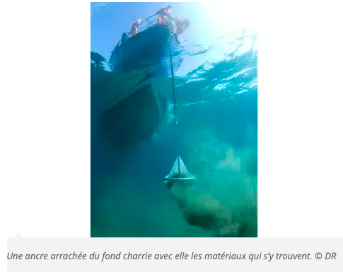
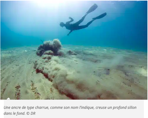
Because the damage caused by the chain, which crawls in light winds to the vertical of the bow, would not be negligible. And because the boat’s position is much easier to control…
6/ How can I find out about mooring bans?
For the moment, the decrees only concern pleasure craft. However, any vessel can be prosecuted if its anchor carries traces of posidonia. To stay within the law, you first need to look where you’re putting your pickaxe: dark seagrass beds are easy to distinguish from white sand on a clear day.
Two applications can help. Nav & Co is the fruit of collaboration between the French Office for Biodiversity (OFB), the French Secretary of State for the Sea, and SHOM. The app (regularly updated) displays up-to-date regulations on the map, with notifications of marine protected areas and environmental regulations. The app also has interactive functions, with photos to identify landmarks and fun, practical information to help you learn more about the marine environment and best practices for preserving it.
Source: