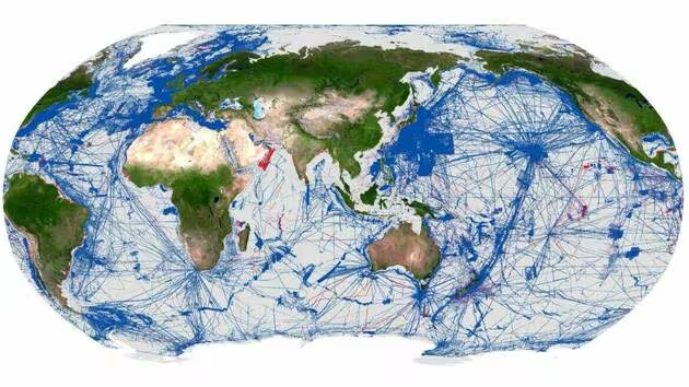
The Seabed2030 ocean mapping project, born in a context of technological evolution, has given a boost to the development of underwater knowledge. In April 2026, 28.7% of the seabed are entered on the general ocean bathymetric map.
The International Hydrographic Organization (OHI), meeting in a three-year meeting this week in Monaco, announced on Monday, April 20, the evolution of knowledge of the world’s seabed, which reaches 28.7% of cartographic coverage.
Since its creation in 1921, the OHI has coordinated the acquisition of global hydrographic data, which today brings to 104 million km2 the area entered on the general bathymetric map of the oceans (Gebco), the last five million km2of which have been added in just one year.
An authoritating reference
Gebco, a joint program of the OHI and the Unesco Intergovernmental Oceanographic Commission (IOC), is the only organization mandated to map the entire seabed.
In 2017, it launched in collaboration with the Nippon-foundation, the Seabed2030 project, which was to accelerate this data acquisition, a key issue for the safety of navigation, climate research, preparedness for unforeseen events and sustainable ocean management
, recalled OHI Executive Secretary and former Norwegian Environment Minister Vidar Helgesen.
For Gebco President Evert Flier, this collaborative and global data set
grid brings together bathymetric data from a wide variety of sources to make it a coherent and authoritative reference
.
Technological developments
Among the top contributors, Malaysia, Morocco, Papua New Guinea and Saudi Arabia, with tripled knowledge of the ROMPE (Persian Gulf) zone, and a significant progression in the Eastern Atlantic, the North Sea, the Mesoamerican Sea and the Caribbean Sea, and the North Indian Ocean.
The technique of satellite bathymetry (calculation of depth in coastal or shallow areas) has been used by some of the 220 organizations that participated in the Seabed2030 project, as well as multi-beam surveys, which provide 360-degree information on the composition of a given environment.
In this great period of uncertainty about the U.S. involvement in science, after significant budget cuts, the National Environmental Information Agency, a branch of the Noaa, did not lift its foot on its contributions and made it possible to advance, even this last year, on the study of the coasts of Alaska, among others.
source : ouest France